0 What 10M Driverless Cars by 2020 Means for Real Estate Development

Driverless car rendering

Credit: TheRealReporter

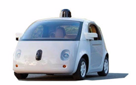
Boston will change significantly with the introduction of driverless cars. Do you expect to own a Level 4 driverless car in the next 10 years?

According to The Real Reporter, “Level 4 cars park themselves, they don’t need nearly the space for error as humans do, and don’t need space for passengers to exit from the sides. As landlords’ see their tenants’ workers go increasingly autonomous, it may make sense to proactively create areas or structures to more efficiently offer car storage than the traditional 150 space per acre parking lot…The autonomous revolution may quickly lead to a car-share model. This could rapidly change industry parking ratios –freeing land, in some cases, for more development!”

You can read more on the real estate impact of driverless cars on The Real Reporter, here.

0 Boston Taxis Launch Smartphone App to Compete with Uber

Boston Taxi

Credit: Boston Business Journal

How do you prefer to traverse the city; Uber, Lift or a yellow taxi?  The taxis of the city are trying to level the field by launching their own app.

According to the BBJ, “the app, which can connect with Apple Pay or Google Wallet, has already launched in Philadelphia and New York City. More than 1,400 of the 1,600 licensed taxis in Philadelphia are already equipped with Verifone payment systems for credit card acceptance and are ready for Way2ride…there are currently 1,825 licensed cabs operating in the city of Boston…A Boston taxi industry group spokeswoman said it was too early to tell if the app would be a step in the right direction. Taxi union spokeswoman Donna Blythe-Shaw said she was more concerned with the fact that taxis are still forced to comply with more stringent and often-complex regulations than ride-hailing services such as Uber and Lyft.

You can read the full article on the Boston Business Journal’s website.

0 Waze will Alert Drivers to the most dangerous intersections in Boston

Waze app showing Traffic in Boston

Credit: BBJ

Should your travels to the office take you or your clients through dangerous intersections, turn to Waze to help you in Boston and 4 other cities.

According to the BBJ, “Waze said the app will alert drivers about intersections with a high-collision rates, high-injury rates, vehicle-to-vehicle incidents, vehicle to bike incident and vehicle-pedestrian incidents…Waze will then overlay its crowdsourced incident reports to calculate the intersections or stretches of road that have the highest comparative risk of incidents and injury to drivers and passengers.”

You can read the full article on the Boston Business Journal website.

0 Green Line Extension Project Gets Boost

Boston Green-line extension project

Credit: GreenlineExtension.eot.state.ma

Boston is home to the old subway in the county, the Green Line, which will be extended by 4.7 miles from Lechmere Station to Somerville and Medford.  This opened at the end of the 19th century and was built to allow ordinary street cars to operate below ground which is dramatically different than subways of today.

The busiest Green Line stop is Park Street station, which is the intersection of the Green, Orange and Red Lines in the heart of Downtown Crossing.

Banker & Tradesman recently reported that the “U.S. Transportation Secretary Anthony Foxx yesterday joined Gov. Deval Patrick and other Bay State officials to formally announce a $996 million federal grant to extend Massachusetts Bay Transportation Authority (MBTA) Green Line light rail service from East Cambridge to Somerville and Medford…The Federal Transit Authority announced its intention to provide nearly $1 billion for the $2.3 billion project in December. State funds will cover the remaining cost.”

You can read the full article on B&T.